 Catálogo de datos del IEO
Contact for the resource
Ifremer, Marine Geosciences
3 record(s)
Type of resources
Categories
Topics
INSPIRE themes
Keywords
Contact for the resource
Provided by
Years
Formats
Status
-
<p>The multi-annual partnership-based research programme SPIRAL (deep seismic and regional investigation in northern Algeria) aims to study the deep structure of the North Algerian margin using "high penetration" seismic methods: low frequency vertical reflection shooting, as well as wide angle reflection and refraction with deployment of listening stations on the seabed and onshore. The first strand of the SPIRAL programme SPIRAL involves the sea cruise to acquire geophysical data. This cruise took place aboard RV L'Atalante in two legs, respectively from 26/09 (Oran) to 10/10 2009 (Annaba) and from 13/10 (Annaba) to 10/11 2009 (Oran). These two legs provided acquisition of wide-angle seismic and penetrating multichannel seismic reflection data, which was the main objective of the project, as well as additional data like very high resolution (Chirp or sediment sounder type), magnetic and gravimetric, and multibeam bathymetric echosounder data. The profiles acquired during SPIRAL should supply elements to characterize the structural levels in and under the sediment cover (crust) down to the mantle in the targeted zones given in the cruise report; obtain accurate images of faulted and folded area and the major boundaries like the Moho; constrain the physical and rheological properties (particularly velocity models) which should help determine things like the nature of the crust at the continent-ocean transition. These constraints will make it possible to perform thermo-mechanical modelling on the scale of the Maghrebide belts to the base of the crust (temperature, density) and thus specify the main boundaries of the large crustal domains.</p>
-

<p>?The cruise took place from 22 November to 20 December 2006 aboard RV L'Atalante. Its objective was to study the formation of passive continental margins and a special sedimentary sequence which exists all over the Mediterranean. The result of national (IUEM Brest, Géosciences Azur, University of Lille, UPMC) and European (Universities of Lisbon and Bologna, GEOMAR and AWI) cooperation, directed by Ifremer, the cruise mobilized some twenty scientists for nearly one month. The related project is GDR Marges.</p>
-
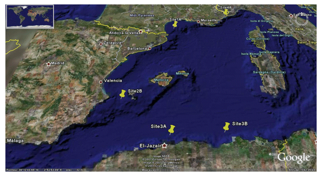
<p>The PRISME cruise objectives were to: - quantify the risk of earthquake-induced sedimentary liquefaction (for areas studied on the Algerian margin and slope off Nice, France); - quantify the risk of instability and failure due to loss of resistance in sensitive clay (slope off Nice); - quantify the risk of slope breaks and erosion caused by bottom currents (canyon heads - gulf of Lion); - identify the triggering factors for slides seen off Ibiza; - and begin to identify the turbidity related to seismic activity along the Algerian margin. This falls under the ANR-Isis an dGDR Marges projects. The cruise took place on 5 sites: Site 1A - Gulf of Lion - North: N 42° 50.00' South: N 42° 40.00' West: E 003° 35.00' East: E 004° 0.00' / Site 2B - Ibiza channel - North: N 38° 39.00' South: N 38° 37.50' West: E 000° 47.00' East: E 000° 51.00' / Site 3A - Alger - North: N 37° 30.00' South: N 36° 40.00' West: E 002° 00.00' East: E 004° 00.00' / Site 3B - Djijel North: N 37° 30.00' South: N 37° 00.00' West: E 005° 00.00' East: E 004° 00.00' / Site 4A - Djijel North: N 43° 40.00' South: N 43° 38.00' West: E 007° 12.00' East: E 007° 15.00'.</p>